Made famous by the Bret Harte story, Outcasts of Poker Flat, which actually has nothing to do with the real town, the name “Poker Flat” will likely at least have name recognition for many people. And to expand on the previous sentence, although the Poker Flat in the story bears no resemblance to the real Poker Flat, it is quite possible that the town served as the inspiration for the Bret Harte story.
The real Poker Flat is located in a deep canyon roughly between La Porte and Downieville. However, unless you have a vehicle able to handle rough roads, Poker Flat is not easy to get to. This is particularly true if you try to access Poker Flat from the route through Howland Flat and Potosi.
The road just before it gets really bad:
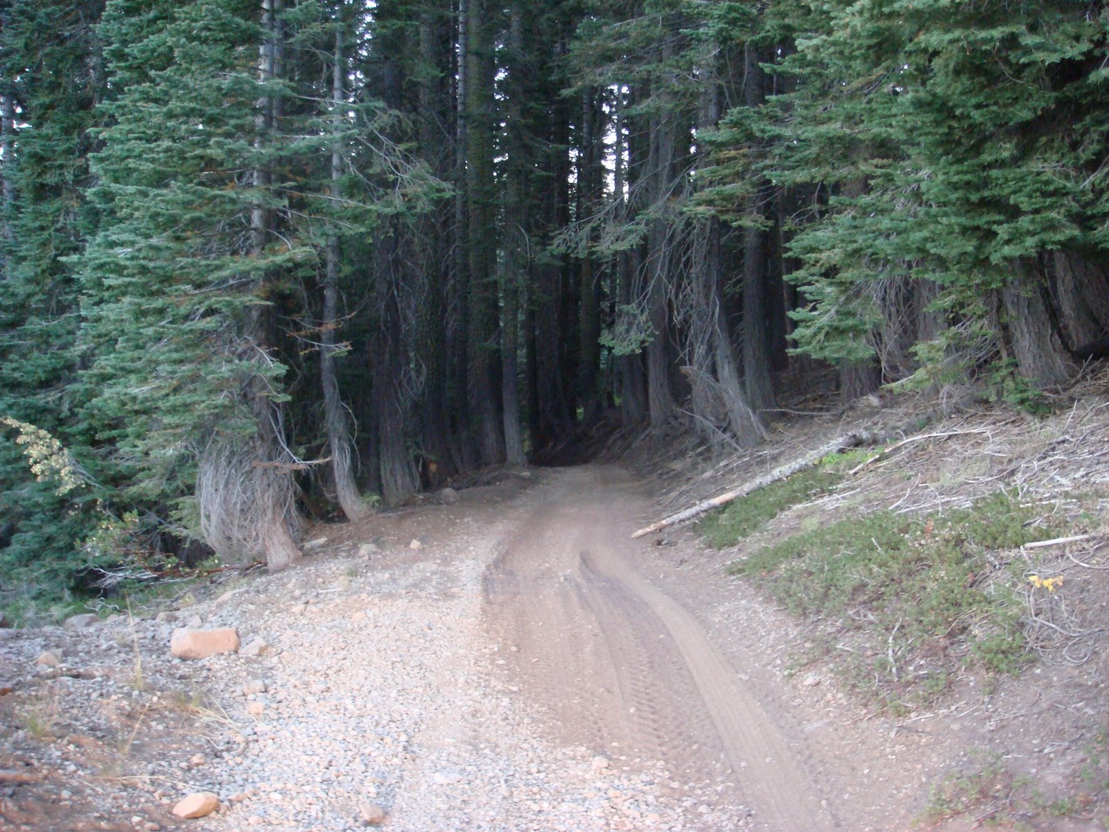
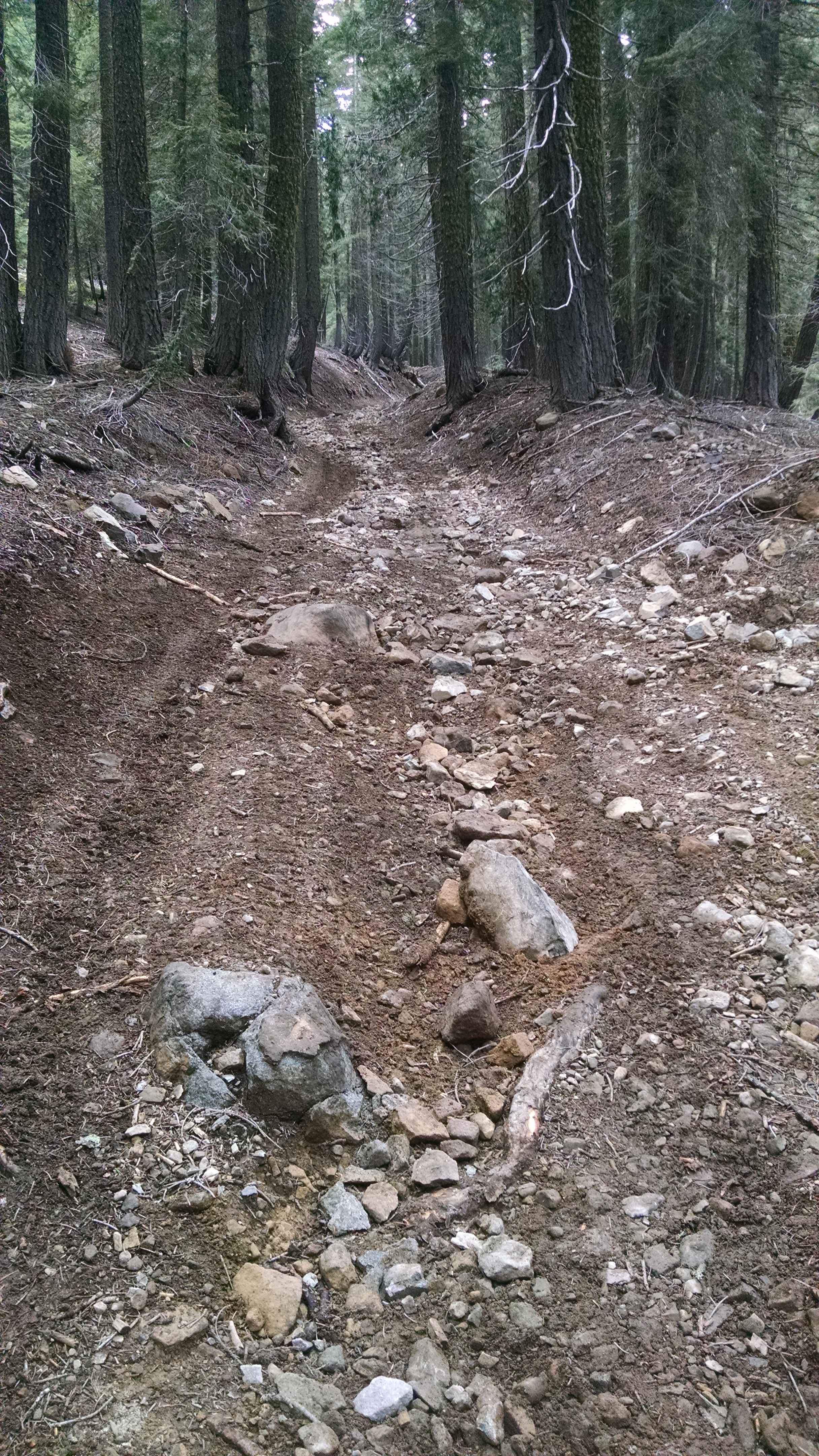
The cliffs leading down to the bottom of the well-named Canyon Creek where Poker Flat was located are extremely steep. Wagon drivers used to drag large logs behind their wagons so that the weight and drag from the logs would prevent the wagons from losing control. Matters have not improved. Today the road leading down to Poker Flat from Howland Flat is little more than a glorified stream bed:
I have been advised that the road coming in from Downieville is slightly better, but I have never taken that route.
Once you reach the bottom of the canyon, you’ll discover that were in not for the massive amount of gold discovered here that Poker Flat is in an odd location for a town as there is hardly any level ground to be found. In fact, there was barely enough space for two rows of buildings with the street between them.
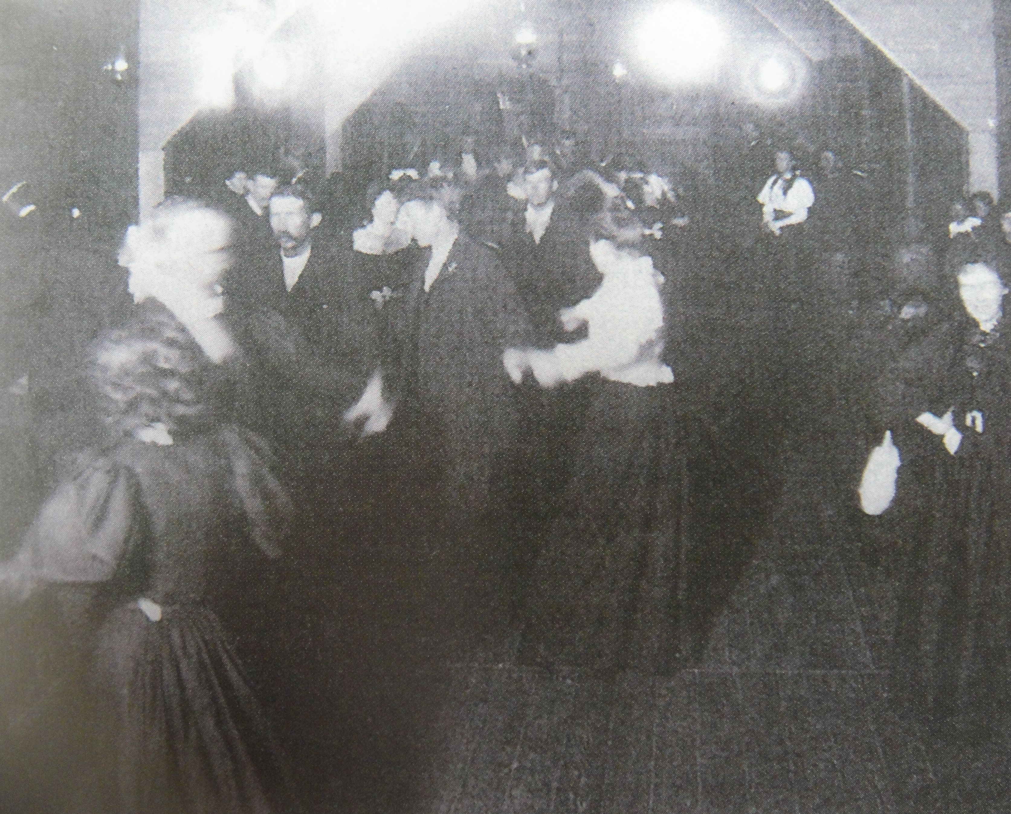
Poker Flat allegedly got its name from the nuggets of gold that were so common in the area that the miners used them as chips in their frequent poker games – hence the mining camp was named Poker Flat. Regardless of the hazy origins of its name, Poker Flat was known as a gambling town and the staggering abundance of gold found in the area was such that it was able to support fifteen saloons and gambling houses, a dozen stores, two butcher shops, a blacksmith shop, concert hall, jewelry shop, Masonic Lodge and three hotels. Miners with their pockets bulging with gold would pour into Poker Flat on the weekends where professional gamblers would be waiting for them to help lighten the heavy burden of carrying such loads of gold around. Sometimes, given the volume of customers, tables had to be set up out in the street.
This picture below from a dance (presumably at the concert hall?) gives some sense of what a lively town Poker Flat was at one time:
Today, when entering Poker Flat from the direction of Howland Flat, this sign is the first thing you will encounter:

Nearby, are the remains of this structure… This was the Charles Scott home. Charles was Poker Flat’s first ski racing champion (skis were called snowshoes back then) and a butcher in Poker Flat:

These pictures were taken in 2007:


Unfortunately, when I was up in Howland Flat being shown around by Jann Garvis and Don Goard two weekends ago, we were advised by a guy that had just made it back up the canyon from Poker Flat that this building had finally succumbed to the elements and collapsed.
*****
If one turns right at the Poker Flat sign pictured above, after a short while you will arrive at a primitive Forest Service campground (there are just picnic tables and fire pits). Nevertheless, it is more than adequate for a stay in the area:

Figuring out the itinerary for the day:

Amusingly, there was another group camped out at the campground when we visited. We figured they would be scary rednecks, but it became immediately apparent when we went over to chat that we were the scary rednecks to them!
That’s me by the campfire… Given how infrequently this area is visited, it is no trouble at all to locate plenty of dead wood around the campground to use as firewood:
")
The next morning we went exploring to the left of the Poker Flat sign…

…and came across this cabin in the woods inhabited by the guy on the left. Neither Ian (the friend I was with) or I could remember the name of the guy on the right – we think it might have been Dale – but he was quite friendly and quite knowledgeable about the area and had helped us the night before with directions. He helped us again with fresh directions when we saw him this time. Interestingly, all of those pictured expressed a strong dislike for hunters and our not being hunters was essentially a precondition to having assistance rendered to us:

There are a few stone foundations and ruins, such as those pictured below, on the road to the left of the Poker Flat sign:

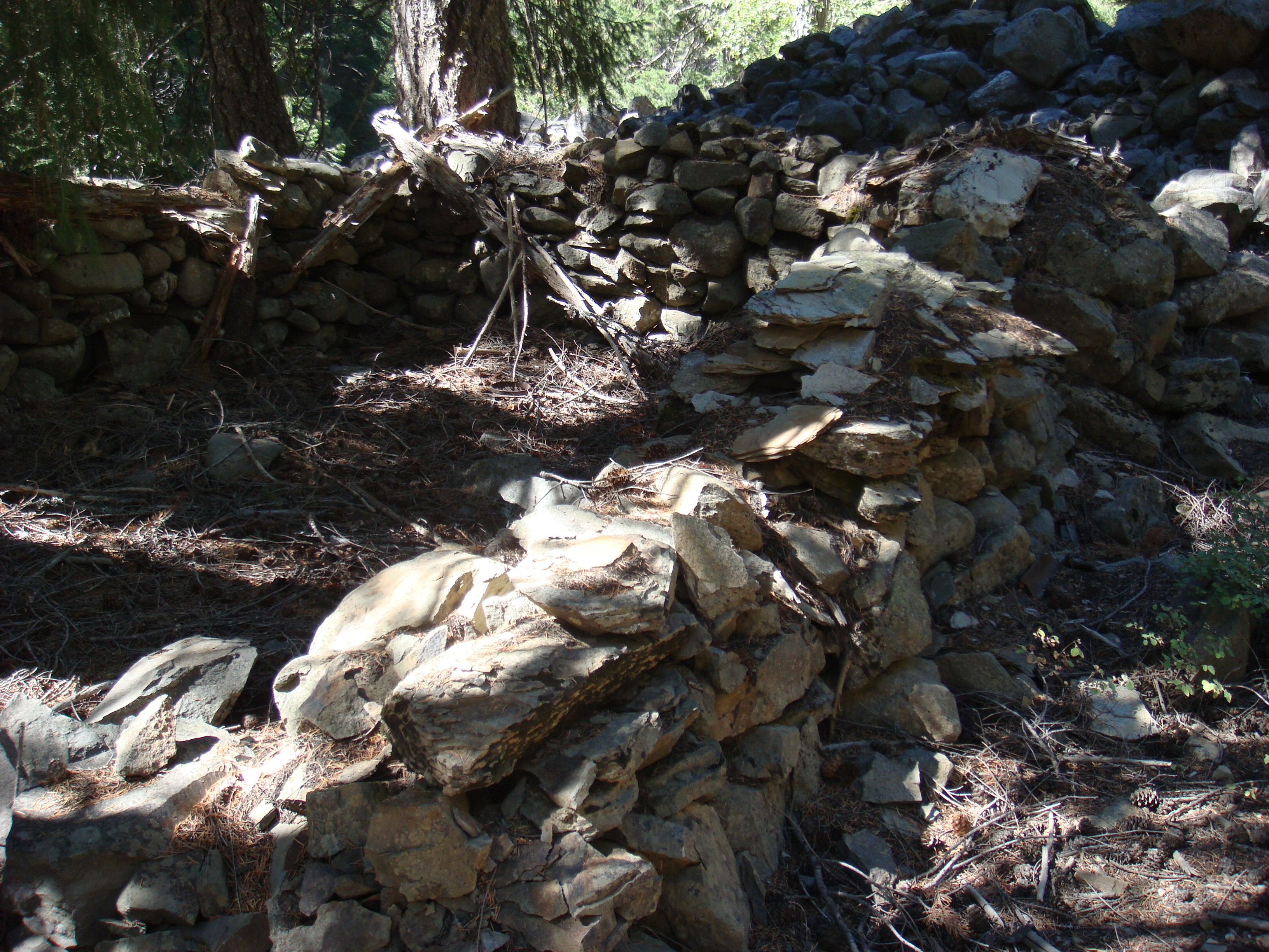
However, overall, there is sadly little left of this once booming community.
The last permanent resident of Poker Flat was Pat O’Kean who lived here until 1950 (he would snowshoe out to La Porte once a week to pick up his mail). After 1950, he would spend early spring until fall here, but leave in the winter. Pat did this up until the 1970s.
All along Canyon Creek itself is extensive evidence of the hydraulic mining that took place in Poker Flat… Ian provides a little scale:

As was typical during the gold rush, the streams around Poker Flat were mined first since that was the easiest. Hydraulic mining then took over on a large scale from the late 1850s through the 1880s. Some hard rock mining (mining using tunnels) took place through the early 1900s and the area was prospected into the 1920s and 1930s.
Poker Flat mines were:
Alturas Gravel
Ballarat
Beaver Gravel
Belmont Consolidated
Big Grizzly Quartz Mine (New York, Poker Flat Gold Mining and Milling Company, Poker Flat Shaft)
Bonanza Extension
Bruckermann (Studhorse Canyon, Blue Lead, Renaissance)
Burnham Consolidated Placer
Captain Cook
Carleton Placer
Carlisle & Company
Cold Canyon (Montrose)
Copper Ledge (Lassiat)
Doray & Company
Descombes Claim (Big Canyon Creek)
Empire Gravel # 2
Enterprise
Fashion No. 1 and No. 2
Forest Queen
Gibraltar (Germania, Eclipse, Divide)
Golden Nugget Gravel
Gordinier & Company
Grand Prize
Happy Day Gravel
Hayes Gravel
Herkimer & Bunker Hill (Enchantress, Evening Star)
Hidden Treasure Hydraulic Mine
Illinois Gravel (Happy-Go-Lucky)
Jones’ New Diggings
Kirkpatrick Claim
Liberator Gravel
Little Grizzly (Kendal & Company)
Luella
Magalio Gravel
Mammoth Quartz Mine
Monterey
No. 2 Quartz (Terhune & Company)
North Bald Mountain
North Side Company
Orleans Gravel Claim
Poker Flat Drift Prospect (Gold Gravel)
Poker Flat Mill and Mining Company
Pyro Group (Hunter)
Rattlesnake Ledge
Reese Ravine
Rocky Point
Sebastopol Gravel
Sierra Company (Sierra Tunnel Company)
Sierra-Phoenix (Alhambra, Sutherland)
Sky High Mine
Soldier Boy
Steamboat
Sunnyside
Sunshine Gravel
Swallow Gravel
Tefft Quartz Mine
Tennessee (Scott & Sons, Conglomerate, Commonwealth, Manxman, Bluebell)
Turner & Company
Waterford Tunnel Mining Company (Quinn Mine)
Wells & Company
West Branch Gravel
Whitehead
Wilsdorff
Winchester Gravel
Wingate
If you are interested in the history of this area, this is a series (search “California Ghost Towns on this site) and I am trying to cover as many towns and as much history as possible in this area of the High Sierra. I am not trying to provide a complete history as Jann Garvis and James Sinnott (I highly recommend both of their books) have covered that ground far better than I. However, given the history rapidly being lost, I hope to show a little of what was once here and to perhaps inspire others to explore and appreciate the rich history of these areas as well.

Nice job Justin. I look forward to our next meeting.
Thank you, Don. I look forward to our next meetup as well.
good article – I’m glad you’re doing a series on these old ghost towns
Ah memories! In the late 60’s my family spent 2 weeks every summer staying with Pat O’Kean (my father was a fly fisherman) . Thanks for the article and pictures!
From everything I’ve heard, that was a great time to be up in Poker Flat or the surrounding environs…
my grandfather has the cabin directly across from the cemetery. I grew up in La Porte and know ea. of those locations well. used to stay with Dick O’Rourke in poker flat and fly fish canyon creek @ copper ledge. I miss those day’s immensely, with Mr O, also miss Leroy post & Jim & Madeline Burkholder, I would sit for hrs and listen to them talk about working in the mines. My father also built the bunk house’s @ the feather fork when it was open in the early 80’s.
Thank you for sharing your memories. You were there for what, at least from my perspective, was a golden time. I’ve had the good fortune to meet some of those characters you mentioned, but I wish I had met them all.
The ‘Cabin’ you two came across is the Mojer (sik) camp/claim. Nicest guy around, and will remember your drink of choice on your next visit.
Thank you, Sev. Do you happen to know the name of the guy at the Mojer? Do you recognize the others in the picture?
Hello Justin, Dale here, the bald guy at the Moser cabin.
I am Maurice Hamilton’s grandson. I spent each summer from 1971 through 1980 there. The last several years at The Clippership near St Louis on Cedar Grove Ravine. If it’s still standing the ore mill in poker flat was the Alhambra mine. I knew Pat Okean. He spent several nights at the Tennessee cabin. We scolded our dog for taking a nip at him and he said ” it’s not his fault! All dogs hate me!” Dick Orourke was an amazing man. I don’t recall copper ledge but he and Earl Twede (sheriff) used to fish at the end of the road past the Tennessee by Blair’s mining claim.I hope to go back someday.
Thank you for adding in those details, Rick. It’s great to have you guys that had/have these connections to the prior generations add in some color.
Hope you get the chance to come back to visit someday… Ha, I’ll warn you that the road from Howland Flat down to Poker Flat is pretty horrendous now though.
That road has always been bad!
Haha, well, you’re certainly right about that. It would’ve been something to see the old wagons making it down there!
Thanks for allowing me to go back in time via this site! I could write a book about those days and the characters involved! It was a great way to spend a childhood full of summers!
I knew Dick o’rourke…and his son still lives in LA porte…I spent many summers ming gold on slate creek…and nearly got into a gun fight in poker flats back in ’84
Glad to hear this place still exists. I used to 4 wheel there in the early 80’s. My son just got a jeep and it’s perfect to get there. I’m looking forward to taking him there.
My wife and I just spend the Labor Day weekend camping at Poker Flat. I couldn’t stop exploring the area and wondering what it must have been like 100 years ago. I was so intrigued that I’ve been doing research since I got home last night. Thanks to all of you for helping me learn a little more about this amazing place. And the fly-fishing is still pretty good…
I went down to poker flat in 1981 with a couple of friends in a jeep pickup. We drank whiskey with a guy named vern overbee. Said he was the mayor! Quite the trip! Dave ward.
It’s hard not to have a good time out there, especially if you run into one of the old-timers…
Ha!Oversbee’s name brings a smile to my face. He had a dragline (like a crane with a bucket attached) that he ran up and down Canyon Creek removing the gravel bed to process for gold. His efforts would often take out the crossing that had to be used when coming through from Downieville. My dad would get so mad when the Toyota got swamped because Vern had made the crossing impassable. Dad would steal the rotor out of his distributor. The motor was some obscure car engine out of the forties which made buying another a huge chore.
Thanks for sharing that, Rick. Great stories like that definitely won’t be making it into the history books and so it is great to get them down in this format…
Pingback: Playing Games » Twelve Mile Circle » maps, geography, travel
I whish I had the money to rebuild poker flat and all the old towns just putem back!!! Does anybody no were the store of Jerome Peyton was?
I whish I had the money to rebuild poker flat and all the old towns just putem back!!! Does anybody no were the store of Jerome Peyton was at poker flat?
Thank you for creating this website. As a kid in the 70’s camped every summer at Sly Creek and explored all the Ghost towns on my motorcycle. Could never find Poker Flat.
30 years later took my kids camping at Little Grass Valley campgrounds every summer. Now with 4WD Expedition found the road to Poker Flat from Howland Flat and made the first attempt. Learned as a kid going down a steep hill is not a good idea unless you can get back up the hill so didn’t go down all the way and turned around. On the way back up a sharp rock went right through the sidewall of my Goodyear Wranglers. Tied it off to a tree and got the tire changed.The next summer equipped with 4 Ply Tires made it down there. and back and later down from the Laporte side and went through to Downieville.
Met a old miner by the name of Wayne in Poker Flat. Said he had been up there since the 50’s and his wife was buried there. Sorry for the long post your website brings back alot of memories.
Nah, man, don’t apologize for the long post. I love hearing memories like this (and a lot of other people do too)… This was great stuff. Thank you for sharing.
A memory that came back to me is my older brother telling me of finding civil war soldiers graves in the Poker Flat area when he went through there in the late 1960’s deer hunting. I have never been able to locate them. Have you heard anything about these? I saw a post in your Howland Flat site where mention was made of a military cemetery in that area but have never run across it over the years.
A question: I am aware that Poker Flat Road is awful between Howland Flat and Poker Flat. Is it any better heading north from Howland Flat to Johnsville McCrea Rd (the Gibsonville townsite)?
I’m afraid that road is completely washed out at Slate Creek… It’s a shame because the road isn’t too bad other than that.
There is a road that takes off from the road to Poker Flat just before it starts to plunge down the canyon, runs behind Mt. Fillmore and then connects up to the Johnsville Road. I have never taken this road though and so I don’t know of the condition that it is in.
It’s tough getting around up there and that is especially the case this season given the winter that we had.
That sucks. Is the washout passable in any vehicle?
Perhaps a tank? There is a ledge that drops off very abruptly for several feet that I have not seen any vehicles ever able to get over… I wish that road were still functional as well because it would make things a lot easier.
Which branch of Slate Creek is that – the one halfway through the road, or the branch right next to Johnsville McCrea?
Because I was there in August, and I noticed a washout at the branch near Johnsville McCrea, but there was a bypass established around that washout, but I did not check any of the other branches…
What about Port Wine road?
I know for a fact that Port Wine and Port Wine Ridge are open and passable as long as you have a high-clearance vehicle that is 4 wheel drive or all wheel drive.
Yes, Port Wine Road is fine. You don’t even need a 4WD…
Port wine was always a better road, just a tad bit longer. You didn’t have to worry about meeting someone in the long grade that might put you on (or over) the cliff. I read on here about cemeteries. I found one near St Louis. It’s just a little back towards town from St Louis. It would be on your right going towards Laporte. Probably a block off of the road. There were white tablet headstones. Wrought iron fence. I recall three gentlemen had died the same day. Also, I was told that at one time there was a tunnel from Howland Flat to poker flat. It was large enough for a wagon to pass through. All of the mining outfits worked together on it so they could haul supplies during winter. I can’t verify it, just what I had been told.
That tunnel running from Poker Flat to Howland Flat is not a myth. It really did exist.
Where did you hear about it?
I grew up in the area and heard the old timers talking about using it as a shortcut to get from Poker Flat to Howland Flat or vice versa. I’ve also had two local historians confirm its existence. I’d love to find it…
That tunnel took off from the Fashion nos 1 and 2 mines several hundred feet north of where sections 3,4,9, and 10 come together at a common point. The portals were about the same distance east also, out of Cold Canyon. The other end was above the Winkeye at Potosi. Mine ventilation was the huge issue. Dead air was a nightmare for the miners. But a through tunnel had upcast and downcast air flow depending on the time.
As I mentioned in earlier post spent summer vacations at poker flat in late 60s and we would stay with Pat O’Kean … I found a few pictures of him … if you would like them… send me your email.
Holly, I would love a picture of Pat. As I said on here before, when dogs would be aggressive with him he would say” it’s not their fault! All dogs bite me!” He would stay at our cabin on occasion at the Tennessee mine. I wish I could recall all the old stories.
I’m wondering, what was the name of the campground you stayed at? Thinking about doing a camping trip in a few weeks and this looks too fun to pass up.
Yes, it is a great area to visit. The campground (that almost belongs in quotation marks) doesn’t have a name that I am aware of… If you make it to Poker Flat, you shouldn’t have any trouble locating it though. We found it in the dark.
thanks for the great article..love that vintage photo!
Awesome pictures Justin. Looks like a great place to camp. Makes you wonder about the all people who lived there back in the day. I’ve been to a few ghost towns on vacation and it was fun to go through all of them. Have you been to the ghost towns and caves up in San Andreas?
Thank you very much. Yes, it is NOT easy to get to, but it is a pretty amazing place… Absolutely loaded with history. There is a fantastic book by Jann Garvis about the town of Poker Flat and the people that used to live here that I would recommend to anyone.
I have seen some of the ghost towns around San Andreas, but I have not seen the caves.
Thanks for the book recommendation. I’ll be sure to check it out. Yeah, the caves are a unique experience. They have 2 tours you can go on. One basic and the one you go through the tunnels to the crystal spring. You get to have a miners hat going through it. You should check it out. At one point you are in total darkness. I plan to go there next year to Poker Flats. I think there was a ghost town up near Paradise or in that area but it got burnt down from the fires.
Crystal spring? That sounds pretty cool… I’d opt for the more in depth tour (obviously). If you ever get out to the wonderful country of Slovenia, check out the Škocjan Caves. They are absolutely mind-blowing – and I don’t say that lightly…
Yes, anything that was around Paradise will not be in the best shape, to be sure. As of now, Poker Flat is still there, but, as I said before, the road down is a ROUGH one.
Greetings from England. I am trying to research a miner/mine owner who left England to mine at Poker Flat. He was called James Freeborough and in 1885 is recorded as being in Alleghany. He was joined by his nephew (whose house we now live in, hence the research) also called James Freeborough and possibly his other nephew Charles Freebough. Any details or suggested leads would be gratefully received. Many thanks.
I’ve been to Poker Flat about a few times over the past 20 years but don’t recall a recognizable cemetery in the town which is odd as Poker Flat is much harder to get to than other Ghost Towns in the area much easier to get to. There is a big cemetery at the top of the mountain coming down the steep road to Poker Flat that is still very prominent with names and where they came from (Many from England). The only town still inhabited in area is La Porte CA. population 26 where they used to have a historical place where their used to be a lady that knew alot of history in the area and might have some historical records. The only other inhabited town close by is Downieville, CA which is many miles away but is where you end up heading on the road out of Poker Flat. There is also a recent book published that is mentioned on this blog that has alot of history of the area. The name Freeborough seems familiar like it might have been mentioned on earlier posts.
Good luck!
Thanks that is helpful. There were two James Freeboroughs, uncle and nephew. Also nephew Charles. They were at Alhambra and Alhambra extension mines I have since found. The nephew James Freeborough died in 1964 in our village, Hartington, UK. Just chasing any other info about the mines and possible records of this family of miners. Thanks again. Stuart
I found this on a link to a newspaper article from June 1912 – James and Charles Freeborough, who lived in Alleghany and Poker Flat, died on the Titanic – they had been visiting their old home in England and were working off their passage as members of the crew.
https://www.theunion.com/news/looking-back-at-june-1912/
Their are also numerous references to their mine. Here’s one from 1903 talking about their mine and extracting 80 ounces of gold in less than 2 weeks time.
https://cdnc.ucr.edu/cgi-bin/cdnc?a=d&d=SFC19030912.2.52&e=——-en–20–1–txt-txIN——–1
Here is a video of a 30 mile trip to Poker Flat. Starts in Downieville and ends up in Laporte the only inhabited towns between Poker Flat. Shows what is left of the town and also the cemetery above Poker Flat.
Rick
Hi Rick, Thanks for the detail regarding the Freeboroughs. From my research it appears that the Titanic link to them is not accurate, early 20th Century fake news possibly ! Will keep trawling through stuff for more info. Have seen the 1950s film The Outcasts of Poker Flat…… gives a feel for the place it was. Do you have the video link you mention as that didn’t seem to be there in the text I received? Thanks again. Stuart
There is a Cemetery I came across in the late 1970’s near the junction of St. Louis and Cedar Grove Ravine. It’s not on any maps.
Sent from Yahoo Mail for iPhone
I own a claim that the Freeborough brothers had. There are two tunnels on the claim. One is collapsed and the other full of water. As I understand the story, the brothers were called back to England to fight in the war. One died in the war and the other perished on the titanic returning to the states.
Thank you for the reply Robert and incredible that you own two of the Freeborough claims. If you have any photos etc. that you would be able to share that would be great. one of the villagers here invested in the mine and we have recently been given the share to add to our research. Sadly the info you have on the brothers does not fit with the info I have. James Stafford Freeborough (one of the brothers and nephew to James Freeborough) did not die in the war but lived until 1963. His brother Charles Freeborough lived until 1944 when he died aged 66. The records from the Titanic don’t appear to have any passengers or crew named Freeborough so I think their association with the ship is more a folklore. As a geologist, and living in the house owned by James Stafford Freeeborough, I am fascinated by his story and think we actually have the head of one of his old mining sledgehammers in the garden. When he died in 1964 and his possessions were auctioned in the field across the road from the house it is rumoured that “a gold bar and a large 6 shot revolver” fell from a set of drawers. Quite a character. Thanks again Robert and if there is anything else you can tell us about the mine or where to find more info etc. I would be very grateful.
I got that information from a book about the area, The roar of the monitors, by Jann Garvis. My claim is a placer claim ( or surface mine) someone else owns the lode claim for the area (underground). I go there quite frequently, what kind of photo’s would you like? Also, if you would, could you give me your email address? I don’t want to post the exact location of the claim on this blog. Cheers! Bob. bgeno@mindspring.com
Hi Stuart, and friends. I am in a position to shed light on what Became of Jim Freeborough. He died early 1917 while on a hike from Poker Flat to Howland Flat to get his mail. He was complaining of feeling unwell before that three mile hike. He made it to the Howland Flat mail office, ( according to them), got his mail and started his return hike. He was never seen again. Body never recovered. The three miles is made up of very challenging steep incline and decline. I’d guess 6000 feet elevation. I sense that his heart gave out, maybe a slip on the icy snow. No one is in a position to know those details.
I go back in time 70 years in Poker Flat. My father was a depression era gold miner there. His oral history to me included the Freeborough details.
Armed with that, I was able to research more details regarding Jim Freeborough’s fate.
In his later years he took to wintering in a milder climate in Santa Cruz California. He seemed active civically and socially. If you research the Santa Cruz Evening News, volume 20, number 62, page 5 July 13, 1917, you will see reference to the circumstance of his passing. If you can search that newspaper’s information, you will see several more detailed paragraphs across the months. Finally, if I recall correctly, six months passed and he was legally declared dead. Hope this fills in some gaps in the information.
I got involved researching Jim’s history in hopes of locating a diary or mine maps or valuation logs for the old Alhambra mine. The other Freeborough relative from Downieville owned the Docile Mine. That mine was a very good one. Had a very successful history. That is another story though.
Cheers
William Anderson
Thank you for the details William. It is fascinating to hear all the info you have. The older James Freeborough was the uncle of James Freeborough who lived in the house we now own. He seems to have been a real character. Thanks again.
Stuart
Stuart, if the geology of the Alhambra mine fascinates you, there is a very well done workup of the mine’s geology. (see the link) The report is not speaking of the Alhambra itself, but rather of the geologic trend in which the Alhambra sits. For all that I can see, the report might as well have been specific to the Alhambra.
http://www.origsix.com/print.asp?id=173
Cheers
William
Thanks again William. Yes, the geology does interest me but fascinated when chasing the suggested press report. Ended up in a website that provides lots of different press reports including the Freeborough. Thanks again.
Perhaps the elusive scary rednecks are just phantoms, a figment of the old hollywood imagination. Meth cookers and mexican drug cartels are probably much more of a nuisance to the area. At any rate this is a cool write up, would love to check it out.
I am headed to Poker Flat in a few weeks. We will be in a JLU Wrangler Rubicon on 35’s and a lifted Gladiator Mojave on 33’s. After camping the night we plan to head over to Plumas Eureka SHP/ Johnsville and want to be there before dinner! My plan was to drive to Howland Flat, then take the rd to Gibsonville, then take the Johnsville- McCree road to Plumas Eureka. I spoke to the County’s regional road manager based at LaPorte who said tge road is open. Any guesses as to how long this would take ( Poker Flat to Johnsville)? thanks! Gary Van Meter garyvm48@gmail.com.